
Posted by
Jon Mortimer manages the Eurobodalla Kayakers website and email list. Eurobodalla Kayakers is not a club. It is simply a facility for sharing information about some kayaking activities in the district, for kayakers who want to know when and where other paddlers might be found on the water. Further information, including a calendar of paddles, is available on the website (access via the link below) or via the email eurobodallakayakers[at]gmail.com
Eurobodalla Kayakers
SHARE URL:
Access Point Description:
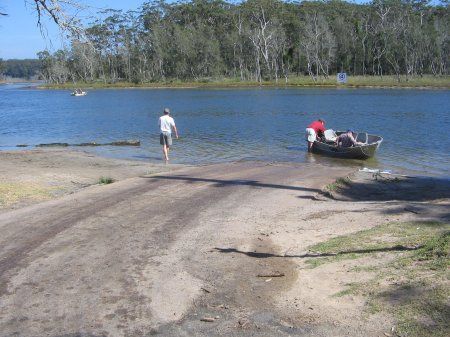
Easy access to Durras Lake from this boat ramp and adjacent sandy bank. Off street parking but few other facilities. Public toilets or kiosk for coffee or supplies requires a short drive into the town of South Durras. To get to the boat ramp turn east from the Princes Highway onto Durras Road. After 6.3km turn left into Durras Lake Road and then after 800m turn left into Lakeside Drive. The boat ramp is at the end of Lakeside Drive. Kayak hire is available from Bay and Beyond Sea Kayak Tours on Lakeside Drive. Visit http://www.bayandbeyond.com.au/kayak/Home.html for more information.
ROAD ACCESS:
Sealed
LAND TENURE:
Council Managed
CLOSEST MAIN ROAD:
Lakeside Drive
WATER ACCESS:
Access off sand/bank
DISABLED ACCESS:
Need Assistance
DISABLED ACCESS DESCRIPTION:
View in Waterways Guide Explorer
Latitude:
-35.645373943713
Longitude:
150.294978115400
Media
South Durras boat ramp on Durras Lake
Jon Mortimer
Wednesday, April 30, 2014 - 04:52