
Posted by
Jon Mortimer manages the Eurobodalla Kayakers website and email list. Eurobodalla Kayakers is not a club. It is simply a facility for sharing information about some kayaking activities in the district, for kayakers who want to know when and where other paddlers might be found on the water. Further information, including a calendar of paddles, is available on the website (access via the link below) or via the email eurobodallakayakers[at]gmail.com
Eurobodalla Kayakers
SHARE URL:
Access Point Description:
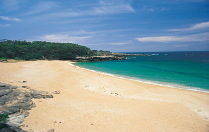
The beaches between South Durras and Batemans Bay face south east. Richmond Beach is probably the easiest beach for landing, but can be subject to powerful dumping surf if a southerly swell is up. Safer landings can be found by continuing south to Batemans Bay or north to Cookies Beach at South Durras. This 380m long beach is accessible via a car park at the northern end.
ROAD ACCESS:
Unsealed
LAND TENURE:
National Parks
CLOSEST MAIN ROAD:
Old Coast Road, from South Durras
WATER ACCESS:
Walk up to 200m
DISABLED ACCESS:
Not Available
DISABLED ACCESS DESCRIPTION:
View in Waterways Guide Explorer
Latitude:
-35.692998584490
Longitude:
150.292472932190
Media