Posted by
Jon Mortimer manages the Eurobodalla Kayakers website and email list. Eurobodalla Kayakers is not a club. It is simply a facility for sharing information about some kayaking activities in the district, for kayakers who want to know when and where other paddlers might be found on the water. Further information, including a calendar of paddles, is available on the website (access via the link below) or via the email eurobodallakayakers[at]gmail.com
Eurobodalla Kayakers
SHARE URL:
Access Point Description:
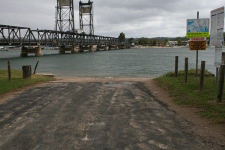
Easy launch directly into the Clyde River / Batemans Bay. The beach has a reasonable gradiant but take care launching as it drops off quickly once on the water. Walk under the bridge to find toilets in Korners Park on the other side of the Highway.
ROAD ACCESS:
Sealed
LAND TENURE:
Council Managed
CLOSEST MAIN ROAD:
Old Punt Road, off Kings Highway
WATER ACCESS:
Access off sand/bank
DISABLED ACCESS:
Need Assistance
DISABLED ACCESS DESCRIPTION:
View in Waterways Guide Explorer
Latitude:
-35.701406645577
Longitude:
150.179787967050