Posted by

The Waterways Guide web developer
The Waterways Guide web developer
SHARE URL:
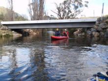
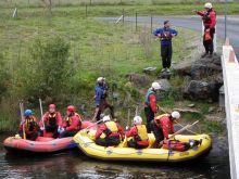
Access Point Description:
There is limited parking at the bridge as there are fences close to the road side. Try to leave most of your vehicles at the exit at Rock Flat Reserve or Thomas boyd Trackhead. Do not park across gateways and as there can be multiple groups on the river on weekends in spring make sure you do not park in other vehicles, leave your car so it can be parked in and park your car so it takes up more than one parking spot..
ROAD ACCESS:
Unsealed
LAND TENURE:
Free public
CLOSEST MAIN ROAD:
Goobarragandra road
WATER ACCESS:
Access off bridge, ford or roadside
DISABLED ACCESS:
DISABLED ACCESS DESCRIPTION:
View in Waterways Guide Explorer
Latitude:
-35.418273000000
Longitude:
148.435478000000