
Eglinton To Freemantle Bridge
Posted by

Published by: The Paddle NSW Inc. PO Box 6971 Silverwater NSW 2128 First published as a book "Canoeing Guide to New South Wales" in 1990 by NSW Canoe Association Incorporated Original Copyright NSW Canoe Association Incorporated 1990 Copyright PaddleNSW Inc. PO Box 6971 Silverwater NSW 2128 Email: admin@paddleNSW.org.au The information on this page and the printed book "Canoeing Guide to New South Wales" is copyright. Apart from fair dealing for the purposes of private study, research, criticism, or review as permitted under the Copyright Act, no part of this page may be reproduced, stored in a retrieval system or transmitted in any form or by any means electronic, mechanical, photocopying, recording or otherwise, without the prior permission of Paddle NSW Inc. All correspondence concerning the content of this guide should be addressed to the Paddle NSW Inc. ISBN O 646 00264 3 The "Canoeing Guide to New South Wales" was printed in Hong Kong by: United League Printing (Hong Kong) Ltd. , Film Separations by: D & S Brandish Print Consultants Typography by: Deblaere Typesetting Pty Ltd., Dee Why, NSW 2099
The Canoeing Guide to NSW Rivers
SHARE URL:
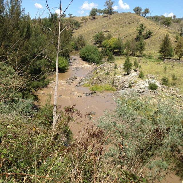
Latest water level:
1.02 m
Level update time:
08-Jul-2026 05:30
WATERWAY:
Macquarie River
ENTRY POINT:
EXIT POINT:
AVERAGE GRADE:
Grade II
HIGHEST GRADE:
TRIP DURATION:
2 days
TRIP LENGTH:
34 km
Gradient:
0
Hot Tip:
Extra caution must e taken high water. Carry drinking water.
Maps:
Shuttle Length:
Portage?:
No
Description:
The river is formed by the joining of the Fish and Campbell's Rivers, the Macquarie River, the largest in the Central Tablelands, is a very popular stream and provides over 180km of whitewater & canoe touring. It contains both easy and more difficult sections, offering something to all grades of canoeists. While flowing through undulating farming country near Bathurst, it later cuts through very hilly and occasionally gorge country as it heads north-west until it flows into Burrendong Dam near Wellington. Leaving the dam it flows in a similar direction through Wellington, Dubbo and finally the Macquarie Marshes Nature Reserve before joining the Barwon River west of Walgett. The historic Bridle Track, the original main road between Bathurst and Hill End during the gold rush era, follows the river closely from Bruinbun to near the Turon junction. The Macquarie is canoeable after good or consistent rain but the level may fluctuate rapidly. Generally it is most reliable in late winter and spring, but good rain at any time of year should ensure a sufficient level. The water is generally clouded by the fine soil of the upper reaches and unfortunately rendered unfit for drinking by the Bathurst discharges. Ensure adequate petrol is obtained at Bathurst or Kelso before proceeding on any of the trips. This section begins very quietly with gently flowing water and long pools in rather scrubby or grassy farming country. A few small races and an easy slide over a rock ledge in the first 1Okm make for a pleasant morning's paddle. A difficult grade 2 rapid, with initially confusing channels among trees and ending with a rocky drop, is now encountered while going around the sharp right-hand corner at 11km. Another kilometre and a left bend brings the paddler to the long bouldery section. The river breaks up into channels, flowing around granite boulders and under trees, with drops and rocky runs with little slack water, making a 1km long grade 2 system. This stretch should be treated with caution in higher water, but is very enjoyable under normal conditions. The country now becomes steeper and wilder, while the river continues at a gentle pace with a few races and easy rapids. At 24km and again at 25km are easy but enjoyable long grade 2 rocky runs. About 1km from Freemantle Bridge is a steep tricky grade 2, and some rocks immediately before the bridge make a fitting end to the section. The river has a sand and gravel bed, and campsites are not of a high standard. See Section 2 for a description of the stretch from Freemantle Bridge to Killongbutta and information on river levels.
Media