

Rock Flat Reserve to The Trout Farm Rapid
Posted by

Published by: The Paddle NSW Inc. PO Box 6971 Silverwater NSW 2128 First published as a book "Canoeing Guide to New South Wales" in 1990 by NSW Canoe Association Incorporated Original Copyright NSW Canoe Association Incorporated 1990 Copyright PaddleNSW Inc. PO Box 6971 Silverwater NSW 2128 Email: admin@paddleNSW.org.au The information on this page and the printed book "Canoeing Guide to New South Wales" is copyright. Apart from fair dealing for the purposes of private study, research, criticism, or review as permitted under the Copyright Act, no part of this page may be reproduced, stored in a retrieval system or transmitted in any form or by any means electronic, mechanical, photocopying, recording or otherwise, without the prior permission of Paddle NSW Inc. All correspondence concerning the content of this guide should be addressed to the Paddle NSW Inc. ISBN O 646 00264 3 The "Canoeing Guide to New South Wales" was printed in Hong Kong by: United League Printing (Hong Kong) Ltd. , Film Separations by: D & S Brandish Print Consultants Typography by: Deblaere Typesetting Pty Ltd., Dee Why, NSW 2099
The Canoeing Guide to NSW Rivers
SHARE URL:
Latest water level:
1.30 m
Level update time:
25-Jul-2026 14:45
WATERWAY:
Goobarragandra River
ENTRY POINT:
AVERAGE GRADE:
Grade II
HIGHEST GRADE:
Grade III
TRIP DURATION:
long half-day or a short day paddle
TRIP LENGTH:
8 km
Gradient:
0
Hot Tip:
Do not trespass on the Trout Farm property.
Maps:
Shuttle Length:
Portage?:
Yes
Description:
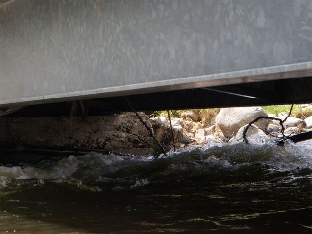
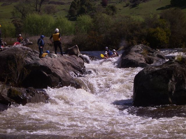
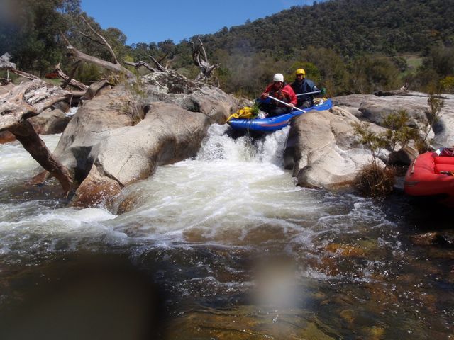
This is a very pleasant section of river which contains many grade 2 and some grade 3 rapids. The first kilometre to the confluence with Stinking Creek (from the left) provides no difficulty. A few hundred metres downstream a low-level bridge can be seen beyond a rapid. http://www.willowwarriors.org.au/images/stories/GOB2MT20041002-04/IM-112... This bridge is quite dangerous . As the water is very swift under the bridge, serious injury may be inflicted 'm 'row water, the problem is less serious but, if the water is at all high the bridge should be portaged. A further 1 km on the "Chute" is reached. This is a drop of about 2m with the water funnelling between rocks which are about 2m apart. This is a very difficult rapid for novices and should be portaged by them. If a capsize occurs in the main drop, paddler and craft should be assisted from the water quickly as there is a large rocky outcrop covered with steel mesh further down where the water divides. Craft full of water hitting the outcrop are in danger of breaking up. For the more experienced paddlers it is an exciting and taxing rapid.
About 1 km below the "Chute" is a twisty rapid which may capsize many novices, mainly because it requires a good deal of negotiating. Capsizes rarely result in problems in low water as there is a large pool at the bottom, but in high water the blackberries along the banks of the fast flowing water make exit difficult. The rapid is best shot on the left side. Between this and the Trout Farm are many grade 2 rapids. Paddlers should familiarise themselves with the features of the Trout Farm rapid while doing the car shuttle so that they can recognise the approach to this rapid from the river in order that tentative paddlers may pull out above it. It is a relatively easy though rocky run in low water, but in higher water a big hole forms near the bottom which cannot be seen from the top due to the curve (to the right) of the rapid. The rapid is approached by taking the main left fork around an island which splits the river. Past the island it is best to veer to the right to avoid the hole at the bottom.
Media

Basil on the Shute 1989
lynnp
Thursday, November 3, 2016 - 07:02
don't doubt this man can paddle!
Goobarragandra Chute between Rock Flat and Thomas boyd at 1.5
jeffcottrell
Wednesday, May 11, 2016 - 23:04
Be prepared early to portage at the lower level bridge
NSW Canoe Guide
Wednesday, April 30, 2014 - 04:52
Alternate route works at the Shute at a very good river level
NSW Canoe Guide
Wednesday, April 30, 2014 - 04:52