
008. Darby's Falls To Cowra
Posted by
SHARE URL:
Latest water level:
1.65 m
Level update time:
07-Jul-2026 15:45
WATERWAY:
Lachlan River
ENTRY POINT:
EXIT POINT:
AVERAGE GRADE:
Grade I
HIGHEST GRADE:
Grade I
TRIP DURATION:
one day, or easily converted to a 2 day trip or two 1 day tr
TRIP LENGTH:
32 km
Gradient:
Hot Tip:
Check the low level bridge Cowra exit point before you start, alternate may be more suitable.
Maps:
Shuttle Length:
The car shuttle, over good roads, is 25km and takes about 30 minutes
Portage?:
No
Description:
During the irrigation season, the river is moderate to fast flowing water with no rapids, through farming country. The banks are lined with willows and gums, and care should taked as there is sometimes blockage with trees across the river requiring portage. These change with each flood event. Sand bars and plenty of eddies provide ready stopping points while on the river.
waypoints along this section are listed on this site. Neila rd, Cudgello ln. , Dukes ln, and Boorowa rd park. These allow entry or exit at sites along the river through public land.
From Darby Falls to the Boorowa River junction there are lots of willows which at times almost choke the river. There are two logs across the river about 1klm fro Darby Falls, which need to be portaged around (Jan 2017). There is also a standing wave 200 m before the Boorowa River junction caused by shallow bedrock, but it is just fun and can be avoided.
About 1.5klm after the Boorowa River junction there is a 100m long island (willows, weeds and long grass). The right hand side has a log across it whch requires portage (Jan 2017), and the LHS has become impassable due to sandbars.
For more information on this section and sections down to Forbes download Steve Howards Lachlan River Maps
Media


Jet boat association of Australia Wyangala and Lachlan river
LachlanPaul
Tuesday, December 20, 2016 - 00:57
Jet boat association of Australia Wyangala and Lachlan river Showing the upper reaches of Wyangala in the Lachlan and in the river below Darbys Falls
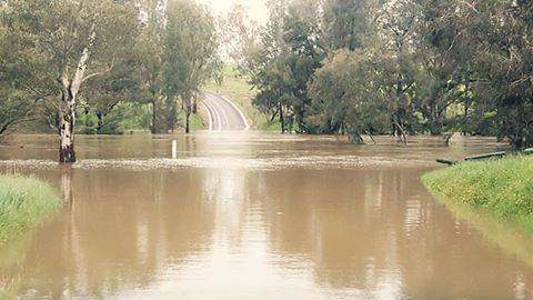
Darby Falls Bridge, River Park in flood at 10.7 m on gauge at Cowra
LachlanPaul
Thursday, September 22, 2016 - 05:18
Darby Falls Bridge, River Park in flood at 10.7 m on gauge at Cowra, 22 Sept 2016
Darbys Falls park River access point
LachlanPaul
Monday, February 29, 2016 - 08:18
Darbys Falls river access point. Small park area of Cowra Wyangala rd.
Junction of Lachlan and Boorowa River
LachlanPaul
Monday, February 29, 2016 - 08:14
Junction of Lachlan and Boorowa rivers just below river park at Darbys Falls Bridge.
Primitive camping overnight in parl
Darbys Falls Park River entry Point
LachlanPaul
Monday, February 29, 2016 - 08:11
Darbys Falls entry exit point from Lachlan River
Darbys Falls Bridge
LachlanPaul
Monday, February 29, 2016 - 08:09
Darbys Falls entry point/exit . Small park, primitive camping overnight. Easy access to river